


V-2019_SEMUR INTRA MUROS

clabidault
User
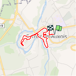

Length
3.3 km

Max alt
290 m

Uphill gradient
53 m
Km-Effort
4 km

Min alt
255 m

Downhill gradient
53 m
Boucle
Yes
Creation date :
2019-05-13 07:42:20.376
Updated on :
2019-05-13 18:58:34.453
1h11
Difficulty : Very easy

FREE GPS app for hiking
 SityTrail
IGN / Geographical institutes
SityTrail Plus
The world is yours!
About
Trail Walking of 3.3 km to be discovered at Bourgogne-Franche-Comté, Côte-d'Or, Semur-en-Auxois. This trail is proposed by clabidault.
Positioning
Country:
France
Region :
Bourgogne-Franche-Comté
Department/Province :
Côte-d'Or
Municipality :
Semur-en-Auxois
Location:
Unknown
Start:(Dec)
Start:(UTM)
600583 ; 5260531 (31T) N.
Comments