


13 mai 2019

jacquesduchesne
User

Length
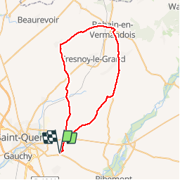
48 km

Max alt
164 m

Uphill gradient
541 m
Km-Effort
55 km

Min alt
78 m

Downhill gradient
540 m
Boucle
Yes
Creation date :
2019-05-13 13:11:40.115
Updated on :
2019-05-13 15:33:31.231
2h20
Difficulty : Very easy

FREE GPS app for hiking
 SityTrail
IGN / Geographical institutes
SityTrail Plus
The world is yours!
About
Trail Bicycle tourism of 48 km to be discovered at Hauts-de-France, Aisne, Mesnil-Saint-Laurent. This trail is proposed by jacquesduchesne.
Positioning
Country:
France
Region :
Hauts-de-France
Department/Province :
Aisne
Municipality :
Mesnil-Saint-Laurent
Location:
Unknown
Start:(Dec)
Start:(UTM)
525467 ; 5519682 (31U) N.
Comments