


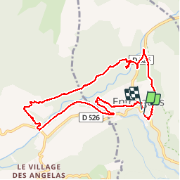
Entraigues

maupassant38
User

Length
9.8 km

Max alt
870 m

Uphill gradient
234 m
Km-Effort
12.9 km

Min alt
737 m

Downhill gradient
231 m
Boucle
Yes
Creation date :
2019-05-14 09:03:48.734
Updated on :
2019-05-14 14:33:29.694
2h36
Difficulty : Easy

FREE GPS app for hiking
 SityTrail
IGN / Geographical institutes
SityTrail Plus
The world is yours!
About
Trail Walking of 9.8 km to be discovered at Auvergne-Rhône-Alpes, Isère, Entraigues. This trail is proposed by maupassant38.
Positioning
Country:
France
Region :
Auvergne-Rhône-Alpes
Department/Province :
Isère
Municipality :
Entraigues
Location:
Unknown
Start:(Dec)
Start:(UTM)
732929 ; 4976114 (31T) N.
Comments