


Calanques J1

rouky
User
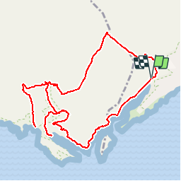

Length
13.2 km

Max alt
210 m

Uphill gradient
552 m
Km-Effort
21 km

Min alt
6 m

Downhill gradient
551 m
Boucle
Yes
Creation date :
2019-05-14 17:19:13.654
Updated on :
2019-05-14 17:20:06.669
4h15
Difficulty : Difficult

FREE GPS app for hiking
 SityTrail
IGN / Geographical institutes
SityTrail Plus
The world is yours!
About
Trail Walking of 13.2 km to be discovered at Provence-Alpes-Côte d'Azur, Bouches-du-Rhône, Cassis. This trail is proposed by rouky.
Positioning
Country:
France
Region :
Provence-Alpes-Côte d'Azur
Department/Province :
Bouches-du-Rhône
Municipality :
Cassis
Location:
Unknown
Start:(Dec)
Start:(UTM)
704878 ; 4787500 (31T) N.
Comments