


Raiatea 1er Rando

jeanmarcMasson
User GUIDE
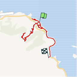

Length
12.3 km

Max alt
272 m

Uphill gradient
308 m
Km-Effort
16.4 km

Min alt
0 m

Downhill gradient
310 m
Boucle
No
Creation date :
2019-05-15 07:48:28.871
Updated on :
2019-05-16 02:51:38.243
7h00
Difficulty : Very easy

FREE GPS app for hiking
 SityTrail
IGN / Geographical institutes
SityTrail Plus
The world is yours!
About
Trail Walking of 12.3 km to be discovered at Unknown, Leeward Islands, Uturoa. This trail is proposed by jeanmarcMasson.
Positioning
Country:
France
Region :
Unknown
Department/Province :
Leeward Islands
Municipality :
Uturoa
Location:
Unknown
Start:(Dec)
Start:(UTM)
665869 ; 8149948 (5K) S.
Comments