


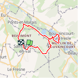
St Pierre en val, circuit du Beaumont

papiou
User


4h30
Difficulty : Difficult

FREE GPS app for hiking
 SityTrail
IGN / Geographical institutes
SityTrail Plus
The world is yours!
About
Trail Walking of 13.1 km to be discovered at Normandy, Seine-Maritime, Saint-Pierre-en-Val. This trail is proposed by papiou.
Description
rdv parking face au cimetière puis face à la porte prendre vers la droite, après 300 mètres partir en forêt, montée très difficile sur 1 bon kilomètres, attention pas de balisage par endroit puis sur le plateau voir site archéologique, descente vers étang de la Bresle, possibilité de faire le tour de l'étang par la gauche avec 3 kms en plus puis retour en passant par ferme Beaumont après une belle montée assez difficile sur 1 km.
Photos


Positioning
Comments