


La rando de St GEORGES 16700

alainjoseph6
User
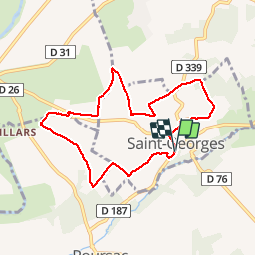

Length
7.9 km

Max alt
125 m

Uphill gradient
78 m
Km-Effort
8.9 km

Min alt
85 m

Downhill gradient
75 m
Boucle
Yes
Creation date :
2019-05-16 12:16:27.91
Updated on :
2019-05-16 14:46:15.17
2h28
Difficulty : Easy

FREE GPS app for hiking
 SityTrail
IGN / Geographical institutes
SityTrail Plus
The world is yours!
About
Trail Walking of 7.9 km to be discovered at New Aquitaine, Charente, Saint-Georges. This trail is proposed by alainjoseph6.
Description
Une magnifique randonnée très venteuse avec des paysages à perte de vue. Nous avons cheminé au milieu des champs des céréales entourés d'une trentaine d'éoliennes.
Photos


Positioning
Country:
France
Region :
New Aquitaine
Department/Province :
Charente
Municipality :
Saint-Georges
Location:
Unknown
Start:(Dec)
Start:(UTM)
288558 ; 5094564 (31T) N.
Comments