


20190516-Le Tour de brionne a detruire

doudet
User
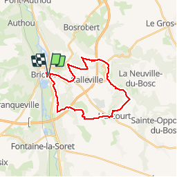

Length
24 km

Max alt
145 m

Uphill gradient
301 m
Km-Effort
28 km

Min alt
57 m

Downhill gradient
302 m
Boucle
Yes
Creation date :
2019-05-16 07:08:49.97
Updated on :
2019-05-16 17:08:59.947
7h22
Difficulty : Medium

FREE GPS app for hiking
 SityTrail
IGN / Geographical institutes
SityTrail Plus
The world is yours!
About
Trail Walking of 24 km to be discovered at Normandy, Eure, Brionne. This trail is proposed by doudet.
Description
Boucle A-R au départ de la Mairie de Brionne
Positioning
Country:
France
Region :
Normandy
Department/Province :
Eure
Municipality :
Brionne
Location:
Unknown
Start:(Dec)
Start:(UTM)
333989 ; 5451502 (31U) N.
Comments