


SaftDamd

dewaeph
User
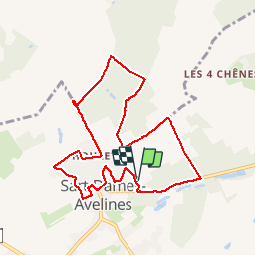

Length
8.5 km

Max alt
164 m

Uphill gradient
125 m
Km-Effort
10.1 km

Min alt
112 m

Downhill gradient
124 m
Boucle
Yes
Creation date :
2019-05-13 11:56:11.248
Updated on :
2019-05-16 16:12:31.436
2h03
Difficulty : Very easy

FREE GPS app for hiking
 SityTrail
IGN / Geographical institutes
SityTrail Plus
The world is yours!
About
Trail Walking of 8.5 km to be discovered at Wallonia, Walloon Brabant, Villers-la-Ville. This trail is proposed by dewaeph.
Positioning
Country:
Belgium
Region :
Wallonia
Department/Province :
Walloon Brabant
Municipality :
Villers-la-Ville
Location:
Sart-Dames-Avelines
Start:(Dec)
Start:(UTM)
606128 ; 5603040 (31U) N.
Comments