


Monthermé Bogny sur Meuse 4 fils Aymon

pjjrevrard
User
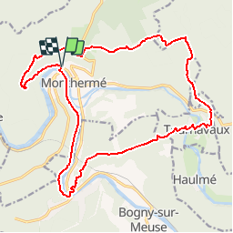

Length
19.6 km

Max alt
423 m

Uphill gradient
713 m
Km-Effort
29 km

Min alt
131 m

Downhill gradient
716 m
Boucle
Yes
Creation date :
2014-12-10 00:00:00.0
Updated on :
2014-12-10 00:00:00.0
5h23
Difficulty : Difficult

FREE GPS app for hiking
 SityTrail
IGN / Geographical institutes
SityTrail Plus
The world is yours!
About
Trail Other activity of 19.6 km to be discovered at Grand Est, Ardennes, Monthermé. This trail is proposed by pjjrevrard.
Positioning
Country:
France
Region :
Grand Est
Department/Province :
Ardennes
Municipality :
Monthermé
Location:
Unknown
Start:(Dec)
Start:(UTM)
624637 ; 5527612 (31U) N.
Comments