


bourget en huile . les kinkins

Gerard.CERDAN
User
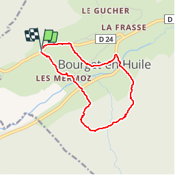

Length
3.3 km

Max alt
909 m

Uphill gradient
132 m
Km-Effort
5.1 km

Min alt
813 m

Downhill gradient
131 m
Boucle
Yes
Creation date :
2019-05-18 07:46:03.063
Updated on :
2019-05-18 09:08:08.625
1h19
Difficulty : Very easy

FREE GPS app for hiking
 SityTrail
IGN / Geographical institutes
SityTrail Plus
The world is yours!
About
Trail Walking of 3.3 km to be discovered at Auvergne-Rhône-Alpes, Savoy, Bourget-en-Huile. This trail is proposed by Gerard.CERDAN.
Positioning
Country:
France
Region :
Auvergne-Rhône-Alpes
Department/Province :
Savoy
Municipality :
Bourget-en-Huile
Location:
Unknown
Start:(Dec)
Start:(UTM)
281059 ; 5040748 (32T) N.
Comments