


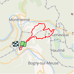
Bogny-sur-Meuse Course à pied tout terrain

choumac08
User

Length
10.8 km

Max alt
393 m

Uphill gradient
587 m
Km-Effort
18.6 km

Min alt
183 m

Downhill gradient
583 m
Boucle
Yes
Creation date :
2019-05-18 09:57:04.244
Updated on :
2019-05-18 09:58:50.688
--
Difficulty : Difficult

FREE GPS app for hiking
 SityTrail
IGN / Geographical institutes
SityTrail Plus
The world is yours!
About
Trail Running of 10.8 km to be discovered at Grand Est, Ardennes, Bogny-sur-Meuse. This trail is proposed by choumac08.
Positioning
Country:
France
Region :
Grand Est
Department/Province :
Ardennes
Municipality :
Bogny-sur-Meuse
Location:
Unknown
Start:(Dec)
Start:(UTM)
625025 ; 5524582 (31U) N.
Comments