


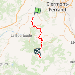
02 GTMC St Bonnet près Orcival-Compains

nicolas54230
User

Length
55 km

Max alt
1292 m

Uphill gradient
1622 m
Km-Effort
76 km

Min alt
805 m

Downhill gradient
1448 m
Boucle
No
Creation date :
2019-05-18 10:39:30.054
Updated on :
2019-05-18 11:06:42.788
1m
Difficulty : Easy

FREE GPS app for hiking
 SityTrail
IGN / Geographical institutes
SityTrail Plus
The world is yours!
About
Trail Mountain bike of 55 km to be discovered at Auvergne-Rhône-Alpes, Puy-de-Dôme, Saint-Bonnet-près-Orcival. This trail is proposed by nicolas54230.
Positioning
Country:
France
Region :
Auvergne-Rhône-Alpes
Department/Province :
Puy-de-Dôme
Municipality :
Saint-Bonnet-près-Orcival
Location:
Unknown
Start:(Dec)
Start:(UTM)
489222 ; 5061622 (31T) N.
Comments