


RANDO 4X4 DU 19 MAI MATIN

association
User
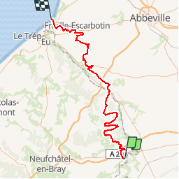

Length
88 km

Max alt
215 m

Uphill gradient
1073 m
Km-Effort
103 km

Min alt
25 m

Downhill gradient
1184 m
Boucle
No
Creation date :
2019-05-18 18:07:01.708
Updated on :
2019-05-18 21:22:23.941
5m
Difficulty : Very easy

FREE GPS app for hiking
 SityTrail
IGN / Geographical institutes
SityTrail Plus
The world is yours!
About
Trail 4x4 of 88 km to be discovered at Normandy, Seine-Maritime, Haudricourt. This trail is proposed by association.
Positioning
Country:
France
Region :
Normandy
Department/Province :
Seine-Maritime
Municipality :
Haudricourt
Location:
Unknown
Start:(Dec)
Start:(UTM)
408675 ; 5511291 (31U) N.
Comments