


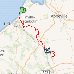
RANDO DU 19 MAI APRES MIDI

association
User

Length
60 km

Max alt
188 m

Uphill gradient
803 m
Km-Effort
70 km

Min alt
29 m

Downhill gradient
647 m
Boucle
No
Creation date :
2019-05-18 18:25:40.862
Updated on :
2019-05-18 21:21:14.376
5m
Difficulty : Very easy

FREE GPS app for hiking
 SityTrail
IGN / Geographical institutes
SityTrail Plus
The world is yours!
About
Trail 4x4 of 60 km to be discovered at Hauts-de-France, Somme, Ault. This trail is proposed by association.
Positioning
Country:
France
Region :
Hauts-de-France
Department/Province :
Somme
Municipality :
Ault
Location:
Unknown
Start:(Dec)
Start:(UTM)
389026 ; 5550966 (31U) N.
Comments