


Brenat les 3 villages

jeanic63
User
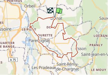

Length
17.8 km

Max alt
527 m

Uphill gradient
346 m
Km-Effort
22 km

Min alt
371 m

Downhill gradient
346 m
Boucle
Yes
Creation date :
2019-05-19 07:38:32.068
Updated on :
2021-04-11 09:32:23.256
5h05
Difficulty : Medium

FREE GPS app for hiking
 SityTrail
IGN / Geographical institutes
SityTrail Plus
The world is yours!
About
Trail On foot of 17.8 km to be discovered at Auvergne-Rhône-Alpes, Puy-de-Dôme, Brenat. This trail is proposed by jeanic63.
Description
départ salle des fêtes à brenat
Positioning
Country:
France
Region :
Auvergne-Rhône-Alpes
Department/Province :
Puy-de-Dôme
Municipality :
Brenat
Location:
Unknown
Start:(Dec)
Start:(UTM)
524069 ; 5044367 (31T) N.
Comments