


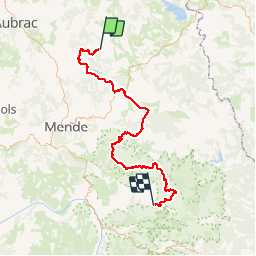
06 GTMC Le Giraldès-Le Pont de Monvert

nicolas54230
User

Length
90 km

Max alt
1561 m

Uphill gradient
1647 m
Km-Effort
113 km

Min alt
873 m

Downhill gradient
2047 m
Boucle
No
Creation date :
2019-05-19 15:27:37.847
Updated on :
2019-05-19 16:05:43.037
15m
Difficulty : Easy

FREE GPS app for hiking
 SityTrail
IGN / Geographical institutes
SityTrail Plus
The world is yours!
About
Trail Mountain bike of 90 km to be discovered at Occitania, Lozère, Arzenc-de-Randon. This trail is proposed by nicolas54230.
Positioning
Country:
France
Region :
Occitania
Department/Province :
Lozère
Municipality :
Arzenc-de-Randon
Location:
Unknown
Start:(Dec)
Start:(UTM)
547213 ; 4946234 (31T) N.
Comments