


Le pont des Romains

c.chehere
User

Length
15.5 km

Max alt
94 m

Uphill gradient
159 m
Km-Effort
17.6 km

Min alt
55 m

Downhill gradient
159 m
Boucle
Yes
Creation date :
2019-05-20 07:20:38.871
Updated on :
2019-05-20 07:45:13.901
3h52
Difficulty : Medium

FREE GPS app for hiking
 SityTrail
IGN / Geographical institutes
SityTrail Plus
The world is yours!
About
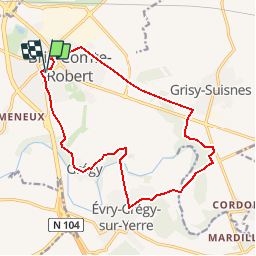
Trail Walking of 15.5 km to be discovered at Ile-de-France, Seine-et-Marne, Brie-Comte-Robert. This trail is proposed by c.chehere.
Description
Départ depuis Brie Comte Robert.
Fiche FFRP77 "EntreYerres et Comilot"
Positioning
Country:
France
Region :
Ile-de-France
Department/Province :
Seine-et-Marne
Municipality :
Brie-Comte-Robert
Location:
Unknown
Start:(Dec)
Start:(UTM)
471222 ; 5392934 (31U) N.
Comments