


entre-canches-et-marais (2)

c.chehere
User
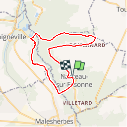

Length
13.6 km

Max alt
127 m

Uphill gradient
148 m
Km-Effort
15.6 km

Min alt
69 m

Downhill gradient
147 m
Boucle
Yes
Creation date :
2019-05-20 07:52:55.827
Updated on :
2025-06-11 06:46:36.825
3h32
Difficulty : Easy

FREE GPS app for hiking
 SityTrail
IGN / Geographical institutes
SityTrail Plus
The world is yours!
About
Trail On foot of 13.6 km to be discovered at Ile-de-France, Seine-et-Marne, Nanteau-sur-Essonne. This trail is proposed by c.chehere.
Positioning
Country:
France
Region :
Ile-de-France
Department/Province :
Seine-et-Marne
Municipality :
Nanteau-sur-Essonne
Location:
Unknown
Start:(Dec)
Start:(UTM)
456849 ; 5351653 (31U) N.
Comments