


V-2019-18-06-Autun la Pierre de Couhard

clabidault
User
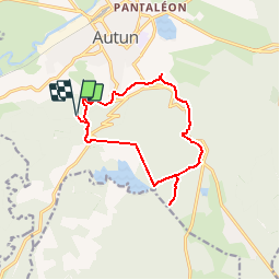

Length
12.5 km

Max alt
600 m

Uphill gradient
305 m
Km-Effort
16.6 km

Min alt
370 m

Downhill gradient
306 m
Boucle
Yes
Creation date :
2019-05-20 16:09:07.14
Updated on :
2019-05-28 19:49:44.275
3h31
Difficulty : Difficult

FREE GPS app for hiking
 SityTrail
IGN / Geographical institutes
SityTrail Plus
The world is yours!
About
Trail Walking of 12.5 km to be discovered at Bourgogne-Franche-Comté, Saône-et-Loire, Autun. This trail is proposed by clabidault.
Positioning
Country:
France
Region :
Bourgogne-Franche-Comté
Department/Province :
Saône-et-Loire
Municipality :
Autun
Location:
Unknown
Start:(Dec)
Start:(UTM)
597983 ; 5198647 (31T) N.
Comments