LAFARE les dentelles de Montmirail

ajasse
User
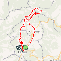

Length
18.7 km

Max alt
725 m

Uphill gradient
761 m
Km-Effort
29 km

Min alt
158 m

Downhill gradient
758 m
Boucle
Yes
Creation date :
2019-05-20 07:45:29.035
Updated on :
2019-05-20 19:39:31.322
6h46
Difficulty : Difficult

FREE GPS app for hiking
 SityTrail
IGN / Geographical institutes
SityTrail Plus
The world is yours!
About
Trail Walking of 18.7 km to be discovered at Provence-Alpes-Côte d'Azur, Vaucluse, Lafare. This trail is proposed by ajasse.
Description
Très belle randonnée avec de très beaux paysages et de belles vues sur les dentelles de Montmirail.
Positioning
Country:
France
Region :
Provence-Alpes-Côte d'Azur
Department/Province :
Vaucluse
Municipality :
Lafare
Location:
Unknown
Start:(Dec)
Start:(UTM)
664051 ; 4890105 (31T) N.
Comments