


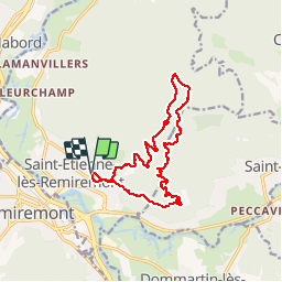
Saint Étienne les Remiremont 15 km

grandville
User

Length
14.3 km

Max alt
790 m

Uphill gradient
605 m
Km-Effort
22 km

Min alt
393 m

Downhill gradient
604 m
Boucle
Yes
Creation date :
2019-05-21 07:22:32.235
Updated on :
2019-05-22 16:06:42.091
6h00
Difficulty : Easy

FREE GPS app for hiking
 SityTrail
IGN / Geographical institutes
SityTrail Plus
The world is yours!
About
Trail Walking of 14.3 km to be discovered at Grand Est, Vosges, Saint-Étienne-lès-Remiremont. This trail is proposed by grandville.
Positioning
Country:
France
Region :
Grand Est
Department/Province :
Vosges
Municipality :
Saint-Étienne-lès-Remiremont
Location:
Unknown
Start:(Dec)
Start:(UTM)
321964 ; 5321726 (32U) N.
Comments