


montagne de Beaune

micheldutilleul
User
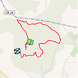

Length
3.6 km

Max alt
400 m

Uphill gradient
66 m
Km-Effort
4.5 km

Min alt
353 m

Downhill gradient
82 m
Boucle
No
Creation date :
2019-05-23 14:13:10.987
Updated on :
2019-05-23 15:56:38.706
48m
Difficulty : Easy

FREE GPS app for hiking
 SityTrail
IGN / Geographical institutes
SityTrail Plus
The world is yours!
About
Trail Walking of 3.6 km to be discovered at Bourgogne-Franche-Comté, Côte-d'Or, Beaune. This trail is proposed by micheldutilleul.
Positioning
Country:
France
Region :
Bourgogne-Franche-Comté
Department/Province :
Côte-d'Or
Municipality :
Beaune
Location:
Unknown
Start:(Dec)
Start:(UTM)
637393 ; 5211950 (31T) N.
Comments