


Vernines haute vallée de la sioule

jeanic63
User
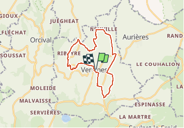

Length
14 km

Max alt
1070 m

Uphill gradient
302 m
Km-Effort
18 km

Min alt
874 m

Downhill gradient
299 m
Boucle
Yes
Creation date :
2019-05-23 11:27:08.132
Updated on :
2021-04-11 09:27:32.259
3h23
Difficulty : Medium

FREE GPS app for hiking
 SityTrail
IGN / Geographical institutes
SityTrail Plus
The world is yours!
About
Trail Walking of 14 km to be discovered at Auvergne-Rhône-Alpes, Puy-de-Dôme, Vernines. This trail is proposed by jeanic63.
Description
départ salle des fêtes à Vernines
Positioning
Country:
France
Region :
Auvergne-Rhône-Alpes
Department/Province :
Puy-de-Dôme
Municipality :
Vernines
Location:
Unknown
Start:(Dec)
Start:(UTM)
490630 ; 5057267 (31T) N.
Comments