


20190523_142610.gpx

raab
User

Length
9.3 km

Max alt
407 m

Uphill gradient
258 m
Km-Effort
12.7 km

Min alt
219 m

Downhill gradient
257 m
Boucle
Yes
Creation date :
2019-05-24 17:50:40.436
Updated on :
2019-05-24 17:53:56.066
2h42
Difficulty : Medium

FREE GPS app for hiking
 SityTrail
IGN / Geographical institutes
SityTrail Plus
The world is yours!
About
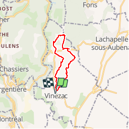
Trail Walking of 9.3 km to be discovered at Auvergne-Rhône-Alpes, Ardèche, Vinezac. This trail is proposed by raab.
Positioning
Country:
France
Region :
Auvergne-Rhône-Alpes
Department/Province :
Ardèche
Municipality :
Vinezac
Location:
Unknown
Start:(Dec)
Start:(UTM)
605286 ; 4932662 (31T) N.
Comments