


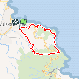
Port de Banyuls, Cap Rederis, bergerie,Seris.

BernardPONS
User

Length
6.8 km

Max alt
201 m

Uphill gradient
275 m
Km-Effort
10.5 km

Min alt
7 m

Downhill gradient
270 m
Boucle
Yes
Creation date :
2019-05-25 13:10:53.224
Updated on :
2019-05-25 16:02:21.493
1h57
Difficulty : Medium

FREE GPS app for hiking
 SityTrail
IGN / Geographical institutes
SityTrail Plus
The world is yours!
About
Trail Walking of 6.8 km to be discovered at Occitania, Pyrénées-Orientales, Banyuls-sur-Mer. This trail is proposed by BernardPONS.
Positioning
Country:
France
Region :
Occitania
Department/Province :
Pyrénées-Orientales
Municipality :
Banyuls-sur-Mer
Location:
Unknown
Start:(Dec)
Start:(UTM)
511003 ; 4702808 (31T) N.
Comments