


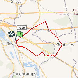
Boves Gentelles

Pascal Piran
User

Length
10.6 km

Max alt
116 m

Uphill gradient
113 m
Km-Effort
12.1 km

Min alt
44 m

Downhill gradient
112 m
Boucle
Yes
Creation date :
2019-05-26 06:04:48.0
Updated on :
2019-05-26 08:01:55.16
1h56
Difficulty : Unknown

FREE GPS app for hiking
 SityTrail
IGN / Geographical institutes
SityTrail Plus
The world is yours!
About
Trail Walking of 10.6 km to be discovered at Hauts-de-France, Somme, Boves. This trail is proposed by Pascal Piran.
Positioning
Country:
France
Region :
Hauts-de-France
Department/Province :
Somme
Municipality :
Boves
Location:
Unknown
Start:(Dec)
Start:(UTM)
456696 ; 5521950 (31U) N.
Comments