


caleyeres

philou68
User
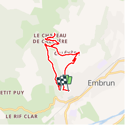

Length
6.8 km

Max alt
1230 m

Uphill gradient
298 m
Km-Effort
10.9 km

Min alt
911 m

Downhill gradient
320 m
Boucle
No
Creation date :
2019-05-26 07:22:42.781
Updated on :
2019-05-26 09:36:38.472
2h13
Difficulty : Easy

FREE GPS app for hiking
 SityTrail
IGN / Geographical institutes
SityTrail Plus
The world is yours!
About
Trail Walking of 6.8 km to be discovered at Provence-Alpes-Côte d'Azur, Hautes-Alpes, Embrun. This trail is proposed by philou68.
Positioning
Country:
France
Region :
Provence-Alpes-Côte d'Azur
Department/Province :
Hautes-Alpes
Municipality :
Embrun
Location:
Unknown
Start:(Dec)
Start:(UTM)
299979 ; 4937429 (32T) N.
Comments