


2013-0801

fredodlageo
User
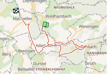

Length
16.1 km

Max alt
326 m

Uphill gradient
258 m
Km-Effort
19.5 km

Min alt
229 m

Downhill gradient
274 m
Boucle
No
Creation date :
2014-12-10 00:00:00.0
Updated on :
2014-12-10 00:00:00.0
57m
Difficulty : Unknown

FREE GPS app for hiking
 SityTrail
IGN / Geographical institutes
SityTrail Plus
The world is yours!
About
Trail Mountain bike of 16.1 km to be discovered at Grand Est, Bas-Rhin, Waldhambach. This trail is proposed by fredodlageo.
Description
Vtt
Positioning
Country:
France
Region :
Grand Est
Department/Province :
Bas-Rhin
Municipality :
Waldhambach
Location:
Unknown
Start:(Dec)
Start:(UTM)
367976 ; 5419684 (32U) N.
Comments