


rando à Pailherols tour des Alpages 10 km

MoiClaude
User
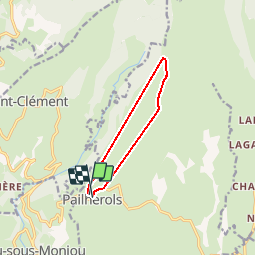

Length
8.8 km

Max alt
1293 m

Uphill gradient
262 m
Km-Effort
12.4 km

Min alt
1035 m

Downhill gradient
271 m
Boucle
Yes
Creation date :
2019-05-27 08:58:30.935
Updated on :
2019-05-27 12:02:18.148
39m
Difficulty : Very easy

FREE GPS app for hiking
 SityTrail
IGN / Geographical institutes
SityTrail Plus
The world is yours!
About
Trail Walking of 8.8 km to be discovered at Auvergne-Rhône-Alpes, Cantal, Pailherols. This trail is proposed by MoiClaude.
Description
Super cool
Positioning
Country:
France
Region :
Auvergne-Rhône-Alpes
Department/Province :
Cantal
Municipality :
Pailherols
Location:
Unknown
Start:(Dec)
Start:(UTM)
475032 ; 4977629 (31T) N.
Comments