


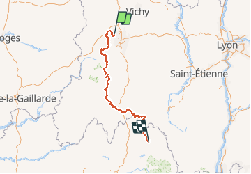
GTMC Volvic-Pont de Montvert

nicolas54230
User

Length
330 km

Max alt
1495 m

Uphill gradient
7699 m
Km-Effort
430 km

Min alt
444 m

Downhill gradient
6907 m
Boucle
No
Creation date :
2019-05-27 12:24:33.798
Updated on :
2019-05-27 12:28:03.679
--
Difficulty : Difficult

FREE GPS app for hiking
 SityTrail
IGN / Geographical institutes
SityTrail Plus
The world is yours!
About
Trail Mountain bike of 330 km to be discovered at Auvergne-Rhône-Alpes, Puy-de-Dôme, Volvic. This trail is proposed by nicolas54230.
Positioning
Country:
France
Region :
Auvergne-Rhône-Alpes
Department/Province :
Puy-de-Dôme
Municipality :
Volvic
Location:
Unknown
Start:(Dec)
Start:(UTM)
503634 ; 5079873 (31T) N.
Comments