


Montigny 2019_06_07

RC76
User
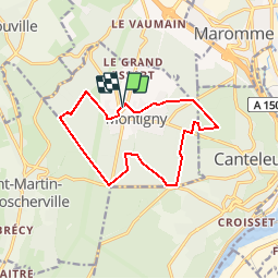

Length
11.6 km

Max alt
149 m

Uphill gradient
152 m
Km-Effort
13.6 km

Min alt
76 m

Downhill gradient
153 m
Boucle
Yes
Creation date :
2019-05-28 08:41:48.727
Updated on :
2019-05-28 08:45:02.921
2h58
Difficulty : Difficult

FREE GPS app for hiking
 SityTrail
IGN / Geographical institutes
SityTrail Plus
The world is yours!
About
Trail Walking of 11.6 km to be discovered at Normandy, Seine-Maritime, Montigny. This trail is proposed by RC76.
Description
tracé de la rando à partir de 2 anciens tracés
Positioning
Country:
France
Region :
Normandy
Department/Province :
Seine-Maritime
Municipality :
Montigny
Location:
Unknown
Start:(Dec)
Start:(UTM)
354770 ; 5480670 (31U) N.
Comments