


Montée de Ste Maxime vers sémaphore

henriantoine
User
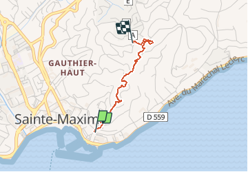

Length
2 km

Max alt
123 m

Uphill gradient
113 m
Km-Effort
3.2 km

Min alt
11 m

Downhill gradient
6 m
Boucle
No
Creation date :
2019-05-28 14:41:04.0
Updated on :
2020-01-11 15:30:44.763
47m
Difficulty : Medium

FREE GPS app for hiking
 SityTrail
IGN / Geographical institutes
SityTrail Plus
The world is yours!
About
Trail Walking of 2 km to be discovered at Provence-Alpes-Côte d'Azur, Var, Sainte-Maxime. This trail is proposed by henriantoine.
Description
Montée depuis Ste Maxime vers sémaphore
Positioning
Country:
France
Region :
Provence-Alpes-Côte d'Azur
Department/Province :
Var
Municipality :
Sainte-Maxime
Location:
Unknown
Start:(Dec)
Start:(UTM)
308767 ; 4797662 (32T) N.
Comments