


Haut du Tôt : cascade Pissoire, église, sentier photo, table orientation 30-05-19

annefrance70
User
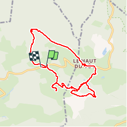

Length
9.1 km

Max alt
857 m

Uphill gradient
235 m
Km-Effort
12.3 km

Min alt
736 m

Downhill gradient
248 m
Boucle
Yes
Creation date :
2019-05-30 09:09:40.264
Updated on :
2019-05-30 13:25:25.38
3h35
Difficulty : Easy

FREE GPS app for hiking
 SityTrail
IGN / Geographical institutes
SityTrail Plus
The world is yours!
About
Trail Walking of 9.1 km to be discovered at Grand Est, Vosges, Vagney. This trail is proposed by annefrance70.
Photos


Positioning
Country:
France
Region :
Grand Est
Department/Province :
Vosges
Municipality :
Vagney
Location:
Unknown
Start:(Dec)
Start:(UTM)
332357 ; 5323396 (32U) N.
Comments