


piste Portet

albaultjl
User
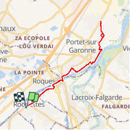

Length
16.7 km

Max alt
161 m

Uphill gradient
125 m
Km-Effort
18.4 km

Min alt
141 m

Downhill gradient
125 m
Boucle
Yes
Creation date :
2019-05-30 12:44:04.541
Updated on :
2019-05-30 15:25:32.283
2h09
Difficulty : Easy

FREE GPS app for hiking
 SityTrail
IGN / Geographical institutes
SityTrail Plus
The world is yours!
About
Trail Mountain bike of 16.7 km to be discovered at Occitania, Haute-Garonne, Roquettes. This trail is proposed by albaultjl.
Positioning
Country:
France
Region :
Occitania
Department/Province :
Haute-Garonne
Municipality :
Roquettes
Location:
Unknown
Start:(Dec)
Start:(UTM)
367722 ; 4817361 (31T) N.
Comments