


VTT Mont Rome......ça monte pour l'ascension

phiphidechagny
User
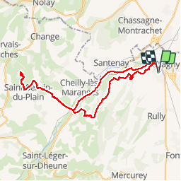

Length
35 km

Max alt
542 m

Uphill gradient
725 m
Km-Effort
44 km

Min alt
214 m

Downhill gradient
725 m
Boucle
Yes
Creation date :
2019-05-30 13:06:08.695
Updated on :
2019-05-30 16:34:30.451
3h26
Difficulty : Medium

FREE GPS app for hiking
 SityTrail
IGN / Geographical institutes
SityTrail Plus
The world is yours!
About
Trail Mountain bike of 35 km to be discovered at Bourgogne-Franche-Comté, Saône-et-Loire, Chagny. This trail is proposed by phiphidechagny.
Positioning
Country:
France
Region :
Bourgogne-Franche-Comté
Department/Province :
Saône-et-Loire
Municipality :
Chagny
Location:
Unknown
Start:(Dec)
Start:(UTM)
632916 ; 5196007 (31T) N.
Comments