


Mandailles

MoiClaude
User
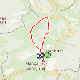

Length
10 km

Max alt
1729 m

Uphill gradient
920 m
Km-Effort
22 km

Min alt
921 m

Downhill gradient
912 m
Boucle
Yes
Creation date :
2019-05-30 08:29:45.221
Updated on :
2019-05-30 17:32:39.26
1h05
Difficulty : Very easy

FREE GPS app for hiking
 SityTrail
IGN / Geographical institutes
SityTrail Plus
The world is yours!
About
Trail Walking of 10 km to be discovered at Auvergne-Rhône-Alpes, Cantal, Mandailles-Saint-Julien. This trail is proposed by MoiClaude.
Description
Rando splendide
Positioning
Country:
France
Region :
Auvergne-Rhône-Alpes
Department/Province :
Cantal
Municipality :
Mandailles-Saint-Julien
Location:
Unknown
Start:(Dec)
Start:(UTM)
472973 ; 4990726 (31T) N.
Comments