


v2

DaVinci
User

Length
2.7 km

Max alt
496 m

Uphill gradient
26 m
Km-Effort
3.4 km

Min alt
368 m

Downhill gradient
132 m
Boucle
No
Creation date :
2019-05-30 16:41:42.251
Updated on :
2019-05-30 19:06:26.519
31m
Difficulty : Very easy

FREE GPS app for hiking
 SityTrail
IGN / Geographical institutes
SityTrail Plus
The world is yours!
About
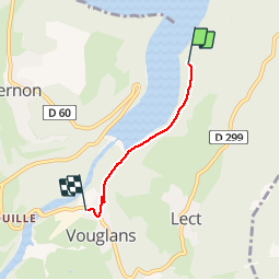
Trail Walking of 2.7 km to be discovered at Bourgogne-Franche-Comté, Jura, Lect. This trail is proposed by DaVinci.
Positioning
Country:
France
Region :
Bourgogne-Franche-Comté
Department/Province :
Jura
Municipality :
Lect
Location:
Unknown
Start:(Dec)
Start:(UTM)
705736 ; 5142587 (31T) N.
Comments