


20130803

fredodlageo
User

Length
7.9 km

Max alt
344 m

Uphill gradient
137 m
Km-Effort
9.5 km

Min alt
230 m

Downhill gradient
52 m
Boucle
No
Creation date :
2014-12-10 00:00:00.0
Updated on :
2014-12-10 00:00:00.0
1h38
Difficulty : Medium

FREE GPS app for hiking
 SityTrail
IGN / Geographical institutes
SityTrail Plus
The world is yours!
About
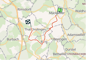
Trail Walking of 7.9 km to be discovered at Grand Est, Bas-Rhin, Mackwiller. This trail is proposed by fredodlageo.
Description
Rando
Positioning
Country:
France
Region :
Grand Est
Department/Province :
Bas-Rhin
Municipality :
Mackwiller
Location:
Unknown
Start:(Dec)
Start:(UTM)
366354 ; 5420566 (32U) N.
Comments