


Boucle Nord Mont St Jean

jeanboulay
User
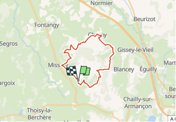

Length
23 km

Max alt
562 m

Uphill gradient
590 m
Km-Effort
31 km

Min alt
374 m

Downhill gradient
591 m
Boucle
Yes
Creation date :
2019-05-31 09:33:36.896
Updated on :
2019-05-31 09:34:24.559
2h02
Difficulty : Medium

FREE GPS app for hiking
 SityTrail
IGN / Geographical institutes
SityTrail Plus
The world is yours!
About
Trail Mountain bike of 23 km to be discovered at Bourgogne-Franche-Comté, Côte-d'Or, Mont-Saint-Jean. This trail is proposed by jeanboulay.
Positioning
Country:
France
Region :
Bourgogne-Franche-Comté
Department/Province :
Côte-d'Or
Municipality :
Mont-Saint-Jean
Location:
Unknown
Start:(Dec)
Start:(UTM)
605982 ; 5238551 (31T) N.
Comments