


Polminhac

MoiClaude
User
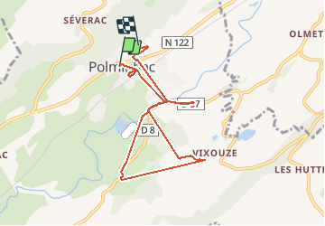

Length
7.9 km

Max alt
794 m

Uphill gradient
263 m
Km-Effort
11.2 km

Min alt
635 m

Downhill gradient
211 m
Boucle
No
Creation date :
2019-05-31 08:36:19.629
Updated on :
2019-05-31 12:31:56.677
54m
Difficulty : Very easy

FREE GPS app for hiking
 SityTrail
IGN / Geographical institutes
SityTrail Plus
The world is yours!
About
Trail Walking of 7.9 km to be discovered at Auvergne-Rhône-Alpes, Cantal, Polminhac. This trail is proposed by MoiClaude.
Description
Rando cool de récupération
Positioning
Country:
France
Region :
Auvergne-Rhône-Alpes
Department/Province :
Cantal
Municipality :
Polminhac
Location:
Unknown
Start:(Dec)
Start:(UTM)
466545 ; 4977662 (31T) N.
Comments