


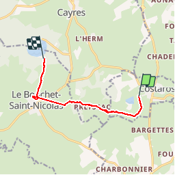
etape 3: costaros --> le bouchet

BernardPONS
User

Length
7.9 km
Boucle
No
Creation date :
2019-05-31 07:45:52.513
Updated on :
2019-05-31 12:33:39.975
1h45
Difficulty : Easy

FREE GPS app for hiking
 SityTrail
IGN / Geographical institutes
SityTrail Plus
The world is yours!
About
Trail Walking of 7.9 km to be discovered at Auvergne-Rhône-Alpes, Haute-Loire, Costaros. This trail is proposed by BernardPONS.
Positioning
Country:
France
Region :
Auvergne-Rhône-Alpes
Department/Province :
Haute-Loire
Municipality :
Costaros
Location:
Unknown
Start:(Dec)
Start:(UTM)
566483 ; 4971259 (31T) N.
Comments