


Etape 3 bis: Landos -->Costaros

BernardPONS
User
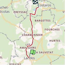

Length
7.1 km

Max alt
1148 m

Uphill gradient
85 m
Km-Effort
8.2 km

Min alt
1090 m

Downhill gradient
87 m
Boucle
No
Creation date :
2019-05-31 12:33:51.076
Updated on :
2019-05-31 14:20:03.721
1h44
Difficulty : Easy

FREE GPS app for hiking
 SityTrail
IGN / Geographical institutes
SityTrail Plus
The world is yours!
About
Trail Walking of 7.1 km to be discovered at Auvergne-Rhône-Alpes, Haute-Loire, Landos. This trail is proposed by BernardPONS.
Positioning
Country:
France
Region :
Auvergne-Rhône-Alpes
Department/Province :
Haute-Loire
Municipality :
Landos
Location:
Unknown
Start:(Dec)
Start:(UTM)
565614 ; 4965937 (31T) N.
Comments