


via fluvia jour2

eoriol
User
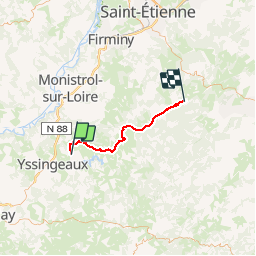

Length
43 km

Max alt
1026 m

Uphill gradient
741 m
Km-Effort
53 km

Min alt
714 m

Downhill gradient
669 m
Boucle
No
Creation date :
2019-05-31 08:29:51.39
Updated on :
2019-06-01 05:16:44.703
4h17
Difficulty : Very easy

FREE GPS app for hiking
 SityTrail
IGN / Geographical institutes
SityTrail Plus
The world is yours!
About
Trail Mountain bike of 43 km to be discovered at Auvergne-Rhône-Alpes, Haute-Loire, Grazac. This trail is proposed by eoriol.
Positioning
Country:
France
Region :
Auvergne-Rhône-Alpes
Department/Province :
Haute-Loire
Municipality :
Grazac
Location:
Unknown
Start:(Dec)
Start:(UTM)
592511 ; 5001550 (31T) N.
Comments