


poitte

DaVinci
User
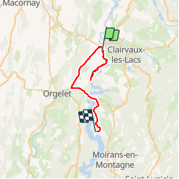

Length
33 km

Max alt
549 m

Uphill gradient
406 m
Km-Effort
38 km

Min alt
428 m

Downhill gradient
304 m
Boucle
No
Creation date :
2019-06-01 08:22:22.01
Updated on :
2019-06-01 12:16:01.377
3h52
Difficulty : Medium

FREE GPS app for hiking
 SityTrail
IGN / Geographical institutes
SityTrail Plus
The world is yours!
About
Trail Canoe - kayak of 33 km to be discovered at Bourgogne-Franche-Comté, Jura, Pont-de-Poitte. This trail is proposed by DaVinci.
Positioning
Country:
France
Region :
Bourgogne-Franche-Comté
Department/Province :
Jura
Municipality :
Pont-de-Poitte
Location:
Unknown
Start:(Dec)
Start:(UTM)
706918 ; 5161933 (31T) N.
Comments