


Sainte Croix

Monjean
User
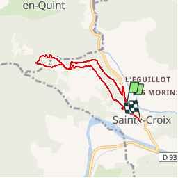

Length
6.1 km

Max alt
552 m

Uphill gradient
191 m
Km-Effort
8.7 km

Min alt
396 m

Downhill gradient
219 m
Boucle
No
Creation date :
2019-06-01 12:22:43.16
Updated on :
2019-06-01 16:53:57.505
2h44
Difficulty : Very easy

FREE GPS app for hiking
 SityTrail
IGN / Geographical institutes
SityTrail Plus
The world is yours!
About
Trail Walking of 6.1 km to be discovered at Auvergne-Rhône-Alpes, Drôme, Sainte-Croix. This trail is proposed by Monjean.
Positioning
Country:
France
Region :
Auvergne-Rhône-Alpes
Department/Province :
Drôme
Municipality :
Sainte-Croix
Location:
Unknown
Start:(Dec)
Start:(UTM)
680344 ; 4960092 (31T) N.
Comments