


lac de monteynard

olivier26
User

Length
13.3 km

Max alt
692 m

Uphill gradient
468 m
Km-Effort
19.5 km

Min alt
470 m

Downhill gradient
457 m
Boucle
No
Creation date :
2014-12-10 00:00:00.0
Updated on :
2014-12-10 00:00:00.0
3h46
Difficulty : Medium

FREE GPS app for hiking
 SityTrail
IGN / Geographical institutes
SityTrail Plus
The world is yours!
About
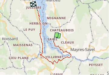
Trail Walking of 13.3 km to be discovered at Auvergne-Rhône-Alpes, Isère, Mayres-Savel. This trail is proposed by olivier26.
Description
tour du lac
Positioning
Country:
France
Region :
Auvergne-Rhône-Alpes
Department/Province :
Isère
Municipality :
Mayres-Savel
Location:
Unknown
Start:(Dec)
Start:(UTM)
712393 ; 4973190 (31T) N.
Comments