


2019-05-21 BERNADETTE

ZAMBAUX
User

Length
18.2 km

Max alt
857 m

Uphill gradient
592 m
Km-Effort
26 km

Min alt
585 m

Downhill gradient
592 m
Boucle
Yes
Creation date :
2019-06-01 17:53:27.139
Updated on :
2019-06-01 17:55:22.912
5h28
Difficulty : Very difficult

FREE GPS app for hiking
 SityTrail
IGN / Geographical institutes
SityTrail Plus
The world is yours!
About
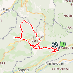
Trail Walking of 18.2 km to be discovered at Grand Est, Vosges, Sapois. This trail is proposed by ZAMBAUX.
Description
Rando avec un dénivelé de 600m
Positioning
Country:
France
Region :
Grand Est
Department/Province :
Vosges
Municipality :
Sapois
Location:
Unknown
Start:(Dec)
Start:(UTM)
335281 ; 5322319 (32U) N.
Comments