


parcours foret de Painpont

cl56
User
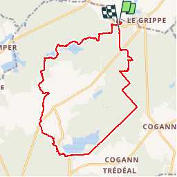

Length
19.1 km

Max alt
179 m

Uphill gradient
159 m
Km-Effort
21 km

Min alt
105 m

Downhill gradient
164 m
Boucle
Yes
Creation date :
2019-06-01 09:27:45.618
Updated on :
2019-06-02 09:38:24.783
6h14
Difficulty : Easy

FREE GPS app for hiking
 SityTrail
IGN / Geographical institutes
SityTrail Plus
The world is yours!
About
Trail Walking of 19.1 km to be discovered at Brittany, Ille-et-Vilaine, Paimpont. This trail is proposed by cl56.
Description
parcours en famille depuis tombeau de merlin
Positioning
Country:
France
Region :
Brittany
Department/Province :
Ille-et-Vilaine
Municipality :
Paimpont
Location:
Unknown
Start:(Dec)
Start:(UTM)
565612 ; 5325353 (30U) N.
Comments