


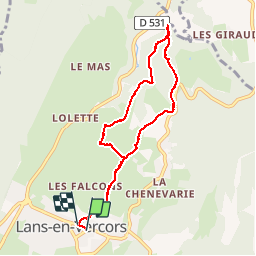
Lans en Vercors - Bec de l'Aigle

maupassant38
User

Length
8.2 km

Max alt
1138 m

Uphill gradient
247 m
Km-Effort
11.5 km

Min alt
985 m

Downhill gradient
248 m
Boucle
Yes
Creation date :
2019-06-02 08:08:00.597
Updated on :
2019-06-02 13:31:12.872
2h08
Difficulty : Easy

FREE GPS app for hiking
 SityTrail
IGN / Geographical institutes
SityTrail Plus
The world is yours!
About
Trail Walking of 8.2 km to be discovered at Auvergne-Rhône-Alpes, Isère, Lans-en-Vercors. This trail is proposed by maupassant38.
Positioning
Country:
France
Region :
Auvergne-Rhône-Alpes
Department/Province :
Isère
Municipality :
Lans-en-Vercors
Location:
Unknown
Start:(Dec)
Start:(UTM)
703822 ; 5000370 (31T) N.
Comments